$92K Providence Map: How 1835 Put the City on the Map
Photo Courtesy of Boston Rare Maps
Every now and then, a piece of New England history reappears from the archives — and when it does, collectors take notice. I’ve written about things just like this before… like people finding rare coins in random items or historic paintings at weekend yard sales.
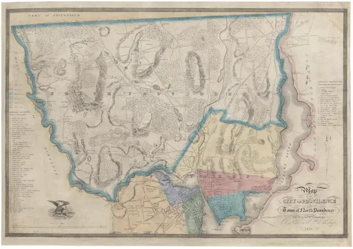
That’s exactly what happened last month at a rare map auction, where an early nineteenth-century plan of Providence, Rhode Island, sold for a staggering $92,000, setting a record for a printed Rhode Island map.
The map, engraved and published by Cushing & Lockwood in 1835, shows a city caught between eras — still compact, yet on the verge of industrial explosion. You can trace the early waterfront, College Hill, and Benefit Street, along with the earliest wharves that powered Providence’s maritime economy. For historians, it’s not just a snapshot of geography — it’s a record of ambition.
What makes this sale remarkable is the story behind the engravers. Cushing & Lockwood were among the first commercial printers in Rhode Island to specialize in cartography, bridging artistry and science in the decades before rail expansion and the Civil War. Their maps were functional tools for surveyors but have since become prized artifacts of civic identity — proof that even then, Providence saw itself as a city worth documenting.
The map’s rediscovery shines a light on how early Rhode Islanders viewed their world. Streets now home to modern condos were once marked as farms and shipyards. “These maps were the Google Earth of their day,” says one curator. “They tell us how people imagined the future.”
Today, that imagination feels alive again — not just in the collector’s market, but in Providence’s continued transformation. A two-century-old map, once folded in a drawer, is now a mirror to how far the city has come.
Custom HTML/CSS/JAVASCRIPT
References
Boston Rare Maps. (2025, August). Plan of the City of Providence, Rhode Island, 1835 — Cushing & Lockwood. https://bostonraremaps.com/inventory/cushing-lockwood-providence-rhode-island-1835
Rhode Island Historical Society Archives. (n.d.). Early Cartography and City Plans of Providence.
Antiques and the Arts Weekly. (2025, Sept 10). Historic Rhode Island Map Sells for $92,000 at Regional Auction.